
Your stack tells you what happened. GeoShield answers where it keeps happening.
Who this is for
For command staff, crime analysts, and GIS managers at municipal PDs and county sheriff's offices evaluating incident management, physical security, public-safety data fusion, and video aggregation platforms. See where each falls short, and what purpose-built, Esri-native law enforcement looks like.
Closing the technology gaps agencies face every day.
01 / 04
Incident management platforms
Strength
Structured dispatch, communications, and reporting workflow. Strong for documenting what happened.
The gap
No native mapping. Command staff can’t see incidents spatially. Analysts work in a different tool.
GeoShield
Layers a GIS-native operational view over your dispatch workflow. Both stay. Both get better.
02 / 04
Physical security suites
Strength
Video management, access control, ALPR, and facility security. Strong for managing cameras and assets.
The gap
Oriented to physical assets, not to crime patterns. Generic workflows that weren’t designed for policing.
GeoShield
Uses your cameras as one data source among many. Adds crime analysis, hotspots, and LE-specific workflows.
03 / 04
Public-safety data fusion platforms
Strength
Broad, vendor-agnostic integration across agencies. Strong for cross-jurisdictional data sharing.
The gap
Built for fire, EMS, and LE at once. Generic workflows. Limited location intelligence and shallow Esri integration.
GeoShield
Purpose-built for law enforcement. Every data point is geographically intelligent, without extra configuration.
04 / 04
Video aggregation platforms
Strength
Real-time video aggregation from public, private, and third-party camera networks. Strong situational awareness in the moment.
The gap
Video tells you what happened, not why it keeps happening. Case management, pattern analysis, and intelligence work live in separate tools. Often hardware-dependent.
GeoShield
Video is one data source alongside CAD, RMS, LPR, and analyst workflows. See crime as it happens, and where it keeps happening.
A unified operational view across every data source.
Dashboard / 01
Real-time operational picture
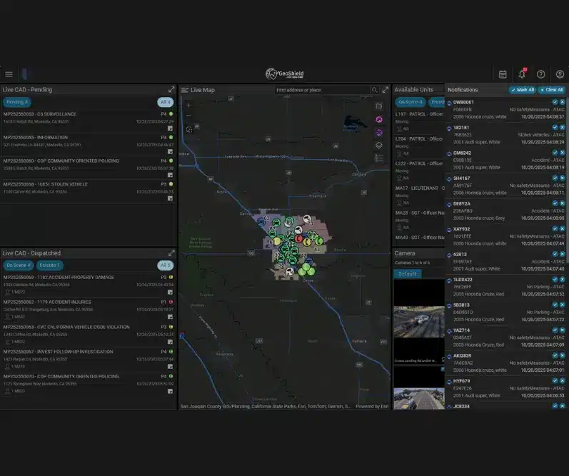
Live CAD events, active units, LPR hits, and camera feeds rendered on a unified map. Command staff see the whole district at once.
For RTCC · Command
Dashboard / 02
Crime patterns, on the map
Hotspot detection, trend analysis, and pattern-based deployment insights powered by native Esri spatial analytics. CAD and RMS auto-publish to your feature layers, ArcGIS Pro add-in included. Analysts stop re-keying.
For Crime Analysts · GIS
Dashboard / 03
Command-level insight
Briefing-ready dashboards, daily activity summaries, and trend reports. Answer “where are we, and what’s changing.” Every morning.
For Chiefs · Command
Dashboard / 04
Community trust & transparency
Public-facing dashboards built on the same data officers use. Transparency that strengthens community relationships without extra lift.
For Chiefs · PIO
Real-time operational picture
Compliance isn’t retrofitted. GeoShield was architected on Azure Government Cloud with CJIS Security Policy standards built into the foundation, not added as an afterthought.
M365 integrated
Seamless integration with the Microsoft 365 ecosystem agencies already run. Single sign-on, shared identity, and the productivity tools your staff uses daily.
Azure Government Cloud
The same infrastructure federal agencies use for sensitive workloads. Enterprise-grade reliability, operational continuity, and a security posture that clears procurement.
The only platform where Esri spatial intelligence meets Microsoft security, without compromise.
GeoShield Esri Better Together
Fourteen capabilities. Five categories. One honest comparison.
| Capability | GeoShield | Incident Mgmt | Physical Security | Data Fusion | Video Aggregation |
|---|---|---|---|---|---|
| Native Esri ArcGIS integration | Full | None | None | Partial | Partial |
| Crime pattern & hotspot analysis | Full | None | None | Partial | Partial |
| Pattern-based deployment insights | Full | None | None | Partial | Partial |
| CJIS compliant | Full | Full | Full | Full | Full |
| Azure Government Cloud | Full | Partial | Partial | None | Partial |
| CAD / RMS fusion on a map | Full | Partial | None | Partial | Partial |
| Auto-publishes CAD/RMS to Esri feature layers | Full | None | None | None | None |
| Live video integration | Full | Partial | Full | None | Full |
| LPR integration | Full | None | Partial | Partial | Full |
| Cloud-native, no hardware required | Full | Partial | None | Partial | None |
| Command-level unified dashboard | Full | Partial | None | Full | Full |
| Mobile app for field officers | Full | Full | None | Partial | Full |
| Works without replacing your stack | Full | Full | Full | Full | Partial |
| Purpose-built for law enforcement | Full | Partial | None | None | Partial |
04 /
Coexistence, by design
We don't replace your stack. We make it useful.
CAD
Real-time ingestion
RMS
Real-time ingestion
LPR
Real-time ingestion
VMS
Live video overlay
AVL
Unit locations
CAD
Real-time ingestion
CAD
Real-time ingestion
CAD
Real-time ingestion
Your force multiplier. Built for your reality.
Do more with the officers, analysts, and budget you already have. GeoShield is engineered for the Tier 3–5 agencies that carry federal-scale responsibility without federal-scale resources.
Sized for your agency
Enterprise capability at mid-market pricing. Purpose-built for municipal PDs serving 50K–500K populations and for county sheriff’s offices that need real-time operational awareness without a federal contract.
Compliant by design
CJIS-compliant and hosted on Microsoft Azure Government Cloud: the only platform where Esri spatial intelligence meets Microsoft security without compromise. Your data stays where it belongs.
Purpose-built, not adapted
Engineered for law enforcement workflows. Not a fire, EMS, or generic public safety platform stretched to fit police work. Every dashboard, every integration, designed with chiefs and analysts in the room.
4
Core Dashboards
RTCA
Real-Time Crime Analysis
CJIS
Compliance Standard
Azure
Gov Cloud Hosted
Questions command staff ask us first.
We already use an incident management system. Do we need this?
You don’t need to replace it. GeoShield layers over your existing incident system and adds the map-centric operational view it doesn’t provide. Your dispatch workflow stays where it is. Your command visibility gets dramatically better.
We already have a video management platform. Isn't this the same thing?
No. A VMS manages cameras. GeoShield uses your cameras as one of many data sources, alongside CAD, RMS, and LPR, to detect crime patterns and power spatial analysis. Video tells you what happened; GeoShield tells you where it keeps happening.
Is our data CJIS-protected?
Yes. GeoShield runs on Microsoft Azure Government Cloud in a CJIS-compliant configuration. All data flows, user access, and storage meet the CJIS Security Policy standards your state expects.
Do you work with our CAD/RMS vendor?
Almost certainly. GeoShield integrates with the major CAD and RMS platforms used across municipal and county law enforcement. Bring the vendor names to your briefing. We’ll confirm on the call.
Does GeoShield require ArcGIS?
Yes. GeoShield uses reference and boundary layers from your existing Esri environment, either ArcGIS Enterprise or ArcGIS Online. If you have CJIS-compliant ArcGIS Enterprise, we integrate more deeply: auto-publishing CAD and RMS data to your feature layers and embedding Esri Law Enforcement dashboards with single sign-on.
What if we don't have ArcGIS Enterprise, or ours isn't CJIS-compliant?
You have options. The base GeoShield deployment works with ArcGIS Online alone and covers all four core dashboards. For agencies that want deeper Esri integration without managing their own ArcGIS Enterprise, we can host and manage a CJIS-compliant ArcGIS environment on your behalf, on Azure Government Cloud.
See the comparison run live. On your data.
30-minute briefing. No sales pressure. Bring your CAD and RMS questions, and the alternatives you’re evaluating. We’ll walk the table line by line.
CJIS Compliant · Azure Gov Cloud · Esri Native · Ethical AI Framework